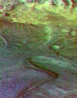
| Mars Surface Layers in Infrared May 29, 2002 PIA 3806 Infrared imaging from NASA's Mars Odyssey spacecraft shows signs of layering exposed at the surface in a region of Mars called Terra Meridiani. The brightness levels show daytime surface temperatures, which range from about minus 20 degrees to zero degrees Celsius (minus 4 degrees to 32 degrees Fahrenheit). Many of the temperature variations are due to slope effects, with sun-facing slopes warmer than shaded slopes. However, several rock layers can be seen to have distinctly different temperatures, indicating that physical properties vary from layer to layer. These differences suggest that the environment on this part of Mars varied through time as these layers were formed. The image is a mosaic combining four exposures taken by the thermal emission imaging system aboard Odyssey during the first two months of the Odyssey mapping mission, which began in February 2002. The area shown is about 120 kilometers (75 miles) across, at approximately 358 degrees east (2 degrees west) longitude and 3 degrees north latitude. NASA's Jet Propulsion Laboratory manages the 2001 Mars Odyssey mission for NASA's Office of Space Science, Washington, D.C. The thermal emission imaging system was provided by Arizona State University, Tempe, in collaboration with Raytheon Santa Barbara Remote Sensing. Lockheed Martin Astronautics, Denver, is the prime contractor for the project, and developed and built the orbiter. Mission operations are conducted jointly from Lockheed Martin and JPL. JPL is a division of the California Institute of Technology in Pasadena. Credit: NASA/JPL/Arizona State University NASA Privacy FAQ Feedback Site Map |

Mars Odyssey's Temperature Maps Expose Rock Layer History May 29, 2002 Surface composition differences in Martian Canyon There are tantalizing indications emerging from the thousands of infrared images taken so far by NASA's Mars Odyssey spacecraft that Mars experienced a series of environmental changes during active geological periods in its history. "We knew from Mars Global Surveyor that Mars was layered, but these data from Odyssey are the first direct evidence that the physical properties of the layers are different. It's evidence that the environment changed over time as these layers were laid down," said Dr. Philip Christensen, principal investigator for Odyssey's camera system and professor at Arizona State University, Tempe. "The history of Mars is staring us in the face in these different layers, and we're still trying to figure it all out." "I expect that the primitive geologic maps of Mars that we have constructed so far will all be redrawn based on Odyssey's new information," said Dr. R. Stephen Saunders, Odyssey's project scientist at NASA's Jet Propulsion Laboratory, Pasadena, Calif. A mosaic of daytime infrared images of the layered Terra Meridiani region shows a complex geology with craters and eroded surfaces, exposing at least four distinct layers of rock. Though the image does not include the infrared "colors" of the landscape (showing surface mineral composition), it does map the temperatures of the features, with surprising results. "With these temperature data, Odyssey has already lived up to our expectations, but Mars, in fact, has exceeded our expectations," said Christensen. "It would have been entirely possible for the rocks of Mars to have been very similar and thus give us all the same temperatures, but Mars has a more interesting story to tell and we have the data to tell it." The images can be seen at: http://www.jpl.nasa.gov/images/mars/index.html and http://themis.asu.edu. Christensen is presenting his findings today at the spring meeting of the American Geophysical Union in Washington, D.C. "When we look at these distinct layers we see that the temperatures are very different, indicating that there are significant differences in the physical properties of the rock layers," Christensen said. The differences in surface temperature could be caused by the fundamental differences in either the size of the rock fragments in the layer, the mineral composition or the density of the layers. Odyssey's imaging team is working on fully processing the infrared images, a complex and difficult task. When finished, the data will help them test some important theories about what causes the layers on Mars by examining the mineral composition of the specific layers. Plausible explanations include a history of volcanic activity depositing layers of lava and volcanic ash; a history of different processes that created the layers through wind and water; or a history of climate change that varied the nature of the materials deposited. Christensen theorizes that the layers are caused not by surface effects, but by changes in the planet's subsurface water table. The presence or absence of water and the minerals carried in it can significantly affect how sediment particles are cemented together. With no clear evidence for surface water, precipitation or runoff, Christensen believes that changes in levels of underground water percolating through layers of buried sediments could account for differences in rock composition between layers. More complete infrared data will help to confirm or disprove this and many other hypotheses concerning Mars' geology. "Looking at craters, we're seeing new distributions of rock on the surface that are helping us understand events in martian geology, and we are getting our first glimpses of 'color' infrared images, which will help us precisely determine the composition of the Mars' surface. This is just the beginning," Christensen said. Additional information about the 2001 Mars Odyssey is available on the Internet at: http://mars.jpl.nasa.gov/odyssey/. JPL, a division of the California Institute of Technology in Pasadena, manages the 2001 Mars Odyssey mission for NASA's Office of Space Science in Washington, D.C. Investigators at Arizona State University in Tempe, the University of Arizona in Tucson and NASA's Johnson Space Center, Houston, operate the science instruments. Additional science partners are located at the Russian Aviation and Space Agency and at Los Alamos National Laboratories, New Mexico. The thermal emission imaging system was provided by Arizona State University in collaboration with Raytheon Santa Barbara Remote Sensing. Lockheed Martin Astronautics, Denver, is the prime contractor for the project, and developed and built the orbiter. Mission operations are conducted jointly from Lockheed Martin and from JPL. Contacts: JPL/Mary Hardin (818) 354-0344 Arizona State University/Jim Hathaway (480) 965-6375 |
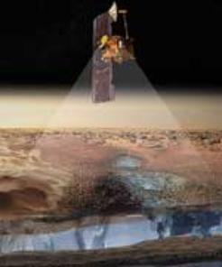
| _________________________________________________________________________________________________________ Odyssey Finds Water Ice in Abundance Under Mars' Surface May 28, 2002 Artist's view of Odyssey detecting ice Using instruments on NASA's 2001 Mars Odyssey spacecraft, surprised scientists have found enormous quantities of buried treasure lying just under the surface of Mars -- enough water ice to fill Lake Michigan twice over. And that may just be the tip of the iceberg. Images are available at http://www.jpl.nasa.gov/images/mars and http://mars.jpl.nasa.gov/odyssey. "This is really amazing. This is the best direct evidence we have of subsurface water ice on Mars. We were hopeful that we could find evidence of ice, but what we have found is much more ice than we ever expected," said Dr. William Boynton, principal investigator for Odyssey's gamma ray spectrometer suite at the University of Arizona, Tucson. Scientists used Odyssey's gamma ray spectrometer instrument suite to detect hydrogen, which indicated the presence of water ice in the upper meter (three feet) of soil in a large region surrounding the planet's south pole. "It may be better to characterize this layer as dirty ice rather than as dirt containing ice," added Boynton. The detection of hydrogen is based both on the intensity of gamma rays emitted by hydrogen, and by the intensity of neutrons that are affected by hydrogen. The spacecraft's high-energy neutron detector and the neutron spectrometer observed the neutron intensity. The amount of hydrogen detected indicates 20 to 50 percent ice by mass in the lower layer. Because rock has a greater density than ice, this amount is more than 50 percent water ice by volume. This means that if one heated a full bucket of this ice-rich polar soil it would result in more than half a bucket of water. The gamma ray spectrometer suite is unique in that it senses the composition below the surface to a depth as great as one meter. By combining the different type of data from the instrument, the team has concluded the hydrogen is not distributed uniformly over the upper meter but is much more concentrated in a lower layer beneath the top-most surface. The team also found that the hydrogen-rich regions are located in areas that are known to be very cold and where ice should be stable. This relationship between high hydrogen content with regions of predicted ice stability led the team to conclude that the hydrogen is, in fact, in the form of ice. The ice-rich layer is about 60 centimeters (two feet) beneath the surface at 60 degrees south latitude, and gets to within about 30 centimeters (one foot) of the surface at 75 degrees south latitude. "Mars has surprised us again. The early results from the gamma ray spectrometer team are better than we ever expected," said Dr. R. Stephen Saunders, Odyssey's project scientist at NASA's Jet Propulsion Laboratory, Pasadena, Calif. "In a few months, as we get into martian summer in the northern hemisphere, it will be exciting to see what lies beneath the cover of carbon dioxide dry-ice as it disappears." "The signature of buried hydrogen seen in the south polar area is also seen in the north, but not in the areas close to the pole. This is because the seasonal carbon dioxide (dry ice) frost covers the polar areas in winter. As northern spring approaches, the latest neutron data indicate that the frost is receding, revealing hydrogen-rich soil below," said Dr. William Feldman, principal investigator for the neutron spectrometer at Los Alamos National Laboratories, New Mexico. "We have suspected for some time that Mars once had large amounts of water near the surface. The big questions we are trying to answer are, 'where did all that water go?' and 'what are the implications for life?' Measuring and mapping the icy soils in the polar regions of Mars, as the Odyssey team has done, is an important piece of this puzzle, but we need to continue searching, perhaps much deeper underground, for what happened to the rest of the water we think Mars once had," said Dr. Jim Garvin, Mars Program Scientist, NASA Headquarters, Washington, D.C. Another new result from the neutron data is that large areas of Mars at low to middle latitudes contain slightly enhanced amounts of hydrogen, equivalent to several percent water by mass. Interpretation of this finding is ongoing, but the team's preliminary hypothesis is that this relatively small amount of hydrogen is more likely to be chemically bound to the minerals in the soil, than to be in the form of water ice. JPL manages the 2001 Mars Odyssey mission for NASA's Office of Space Science, Washington, D.C. Investigators at Arizona State University, Tempe; the University of Arizona, Tucson; and NASA's Johnson Space Center, Houston, operate the science instruments. The gamma-ray spectrometer was provided by the University of Arizona in collaboration with the Russian Aviation and Space Agency, which provided the high-energy neutron detector, and the Los Alamos National Laboratories which provided the neutron spectrometer. Lockheed Martin Astronautics, Denver, developed and built the orbiter. Mission operations are conducted jointly from Lockheed Martin and from JPL, a division of the California Institute of Technology in Pasadena. Additional information about the 2001 Mars Odyssey and the gamma-ray spectrometer is available on the Internet at: http://mars.jpl.nasa.gov/odyssey/ and http://grs.lpl.arizona.edu. Contacts: JPL/Mary Hardin (818) 354-0344 NASA Headquarters/Don Savage (202) 358-1727 University of Arizona/Heather Enos (520) 621-8279 MARS - CONTINUED ON NEXT PAGE |
| Mars Photos and Further Investigations 2002 and Now 2004..and Still Waiting for Answers |
MARS LINKS Created by Mary
Sutherland
Kivas
Kivas 2
Spirit Mars
Spirit Mars 2
Spirit Mars 3
Spirit Mars 4
Spirit Mars 5
Spirit Mars 6
Spirit Mars 7
Spirit Mars 8
Spirit Mars 9
Spirit Mars 10
Spirit Mars 11
Spirit Mars 12
Spirit Mars 13
Spirit Mars 14
Spirit Mars 15
Spirit Mars 16 - Mars Update
Spirit Mars 17 - Mars Fossils
Spirit Mars 18 - Mars from
Wisconsin
Spirit Mars 19 - Mars from
Wisconsin
Spirit Mars 20 - Mars from
Wisconsin
Spirit Mars 21 - Mars from
Wisconsin
Spirit Mars 22 - Mars from
Wisconsin
Spirit Mars 23 - Mars from
Wisconsin
MARS Exploration and
Coverups
Cydonia Decoded
Mars Explorations
Mars Images
| Inter-dimensional Photos Taken in the Haunted Woods of Burlngton, Wisconsin Burlngton Tours - Brad and Mary Sutherland Click Here for More information on Tours |
| Mars and Earth Connection by Mary Sutherland Exploring the Unknown with Mary Sutherland |
| Brad and Mary Sutherland 248 Carver Street Winslow, Illinois 61089 815 367 1006 |

| Allow me to Introduce Myself .... Click Here |
| Portals...Gateways to the Multi-Dimensional Worlds 19.99 120 pages Full Color Portals- Gateways to the Multi-Dimensional Worlds Believe in the Magic Series In reading my book, ‘Portals- Gateways to the Multi-Dimensional Worlds’ and my series ‘Believe in the Magic’, I assure you, that you will not be disappointed. Quite the opposite; this book and upcoming series offer to the reader a unique understanding of ‘All that Is!’ Spread throughout its pages, are photos my husband Brad and I have taken through the years of the invisible worlds, filled with multiple selves, faeries, trolls, UFOs, angels and more. |


